Waldo Canyon Fire
by: The Calamity Calendar Team
June 23, 2012
Smoke on the Horizon
Late June in Colorado, when the land is supposed to quiver with the expectation of summer storms, the skies instead hung in a dry, relentless blue. On June 23, 2012, residents west of Colorado Springs noticed something new on the horizon: a thin curl of smoke rising where forest met foothills, somewhere deep in the snarl of Pike National Forest. For a time, most did what people do—they checked the distance, wondered about a lightning strike, and went back to their business.
But with the ground crisp underfoot since spring and the air itself feeling sharp, as though charged with static, this small puff of smoke carried a warning that no one could ignore for long.
Season of Drought
Colorado is no stranger to wildfire. That spring had been kindling for disaster—low snowpack, little rainfall, and days upon days where sun and wind worked together to bleach the mountain grass and dry out every needle on every ponderosa pine. "Extreme" was not just a forecast but an official designation: the forests were now ready to burn.
Colorado Springs, the state’s second-largest city and a magnet for newcomers, had also grown in a very particular way. People wanted easy access to hiking trails and dramatic mountain views—so new neighborhoods like Mountain Shadows spread west, pressing houses and winding cul-de-sacs up against thick timber and steep slopes. In the fire service, they call this the “wildland–urban interface.” To most, it just looks like a beautiful place to raise a family.
But beauty, as so often in Colorado, came with a catch. Steep land and heavy brush wrap tightly around these neighborhoods, setting up a dangerous game: if fire came, it would not creep. It would move like a living thing, quick and unpredictable.
Fire Ignites
Just after noon on June 23, the call came in—a wildfire near Waldo Canyon, the recreation area just outside of town. At first, it was measured in hundreds of acres. Emergency crews scrambled in battered trucks and hauled water up narrow switchbacks. The terrain was so rugged, early responders could not reach the flames by road. Retardant drops from tankers barely dented the growing column of smoke.
Thanks for subscribing!
By nightfall, the fire had multiplied tenfold. Over 2,000 acres were burning. Ash started to fall like dry snow on parked cars.
The Lines Hold—Then Fail
Over the next two days, fire crews threw themselves at the spreading flames. Hiking trails—normally jammed with families and tourists—were roped off, evacuation orders issued for Manitou Springs and the little communities tucked in draws among the red rocks. Helicopters hammered the fire with water from above while firefighters on the ground clawed out containment lines wherever possible, trying to wrestle an advantage from the wind and the trees.
The weather, however, had other plans. On June 26, in the dry heat of the afternoon, the winds over Rampart Range shifted and gained force. Gusts whipped up from the western hills, driving bright orange fingers over every natural and manmade barrier.
The Waldo Canyon Fire broke loose. For people living in Mountain Shadows and along the city’s edge, there was little warning. The flames, stoked by 65 mile-per-hour winds, roared down the hillsides faster than any human could run. In hours, the firestorm jumped the containment lines and poured into the city.
The Night Colorado Springs Burned
Evacuation orders turned urgent. Police moved door to door, urging families to grab what they could: pets, photo albums, a change of clothes. Some left with only the shirts on their backs.
What followed was impossible to process in real time. Streets familiar for decades were devoured in minutes. Cameras captured what words could barely contain: walls of flame a hundred feet tall, smoke so thick it turned afternoon to dusk, and sirens harmonizing with the crack of burning timber and the shatter of windows popping in the heat.
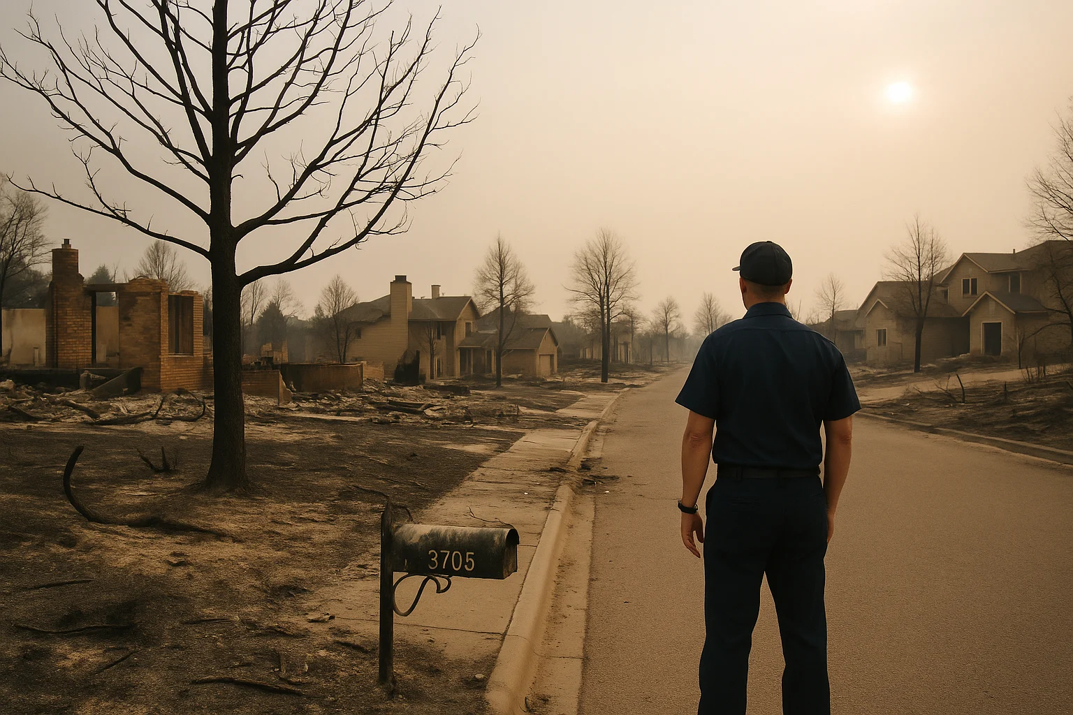
In Mountain Shadows, fire leapt between houses and through wooden fences, surging downhill with the wind’s full blessing. By dawn, entire blocks were reduced to smoking foundations. 346 homes were destroyed in one day—the largest such loss in Colorado history up to that moment. A handful of other outbuildings went with them. Miraculously, as the fire advanced, emergency shelter workers and animal agencies worked around the clock to save as many pets and livestock as possible, even as flames pushed their teams back.
But not everyone made it out. Two residents died—caught in the surge after refusing to evacuate. Dozens of pets were lost. Many more would turn up days and weeks later, confused, in shelters, or, in some cases, not at all.
Battling the Beast
After the fire’s worst night, crews redoubled their efforts—not just to hold new lines, but to protect what remained. At the fire’s peak, over 1,500 firefighters, some local, many called in from across the country, worked shifts that sometimes stretched into exhaustion. Aircraft crisscrossed the city’s western perimeter, flying so low residents could see the pilots’ faces.
Day after day, the fire crept and surged, now boxed in by the tireless effort of ground crews and, mercifully, a subtle shift toward cooler, calmer weather. Gradually, officials were able to shrink evacuation zones, letting some families go back to see what, if anything, remained.
On July 10, 2012, fire commanders announced the Waldo Canyon Fire was finally, fully contained. In total, it consumed more than 18,000 acres—nearly 29 square miles.
Picking Up the Pieces
Recovery began where the fire ended, often in silence: neighbors picking through the powdery remains of former homes, firefighters standing with helmets off in blackened lots, just for a minute, before moving on.
The numbers were staggering. Final tallies listed 346 homes destroyed, with the bulk in Mountain Shadows. Another handful of businesses and outbuildings gone. Insurance losses soared past $350 million; costs to battle the fire itself landed near $15 million. Local businesses closed. Highways grew quiet. The region’s summer tourism—the lifeblood of Manitou Springs and the Garden of the Gods—withered as the world saw the flames on TV and decided, understandably, to stay away.
Nature suffered, too. Wildlife counts went unreported—how do you tally the deer, birds, and smaller creatures who never made it out? What was clear was that in the areas scorched most fiercely, decades would pass before pine needles softened the ground again.
Relief, Response, and Resilience
Emergency headquarters became temporary cities: cots lined up in high school gyms; churches and temples opening their doors; restaurants offering meals and a place to sit. The entire city felt the loss—not only of homes and property, but of the ordinary feeling of security that separates one day from the next.
Recovery was as much about policy as about people. The city, county, and state—alongside federal agencies—launched a massive cleanup and restoration effort: clearing ash and debris, hauling away ruined cars, and, almost immediately, starting work on new erosion barriers to keep the coming rains from washing more of the hillsides down onto the houses below. Without trees to hold the soil, floods often follow quickly after fire.
Officials didn’t wait for the next spark. New building codes were written, requiring more fireproof materials and greater spacing in hillside neighborhoods. Homeowners, newly wise to the risks, hauled brush and trees back from fence lines—creating “defensible space.” The fire department launched risk-awareness campaigns and improved emergency alert systems, hoping the next time might not be so devastating.
Questions Unanswered
From the earliest days of the fire, investigators hunted for a definitive cause, combing through singed undergrowth in hopes of uncovering evidence. Lightning was ruled out within hours; all signs pointed to a human hand—whether by accident or with intent, no one could say for sure. Even now, over a decade later, no official cause has ever been announced.
But for those who lived through it, this question—important as it is—took a back seat to the how and the why. Why was the city so vulnerable? How could destruction happen so quickly, and what could be learned, if anything, to make sure it never happened again?
The Fire’s Shadow
Today, the scars of the Waldo Canyon Fire are still visible—bare bands on the hillsides above western Colorado Springs, a distinct border between the green of new growth and the gray where the trees once stood. Some streets were rebuilt, neighbors returned. Others left Colorado, the memories too much.
What remains is a kind of vigilance. Wildfire, once thought of as a rare disaster, is now a perennial concern along the Front Range. City planners and homeowners look at fire maps when they buy, and children practice evacuation drills at school. Water storage tanks have been built on hillsides. New public lands management plans have changed the way tracts of forest are thinned and managed.
In the stories of those days—the narrow escapes, the bravery of crews who stood their ground, and the generosity of strangers—Colorado Springs found itself tested and, in a sense, changed. The Waldo Canyon Fire forced a reckoning with the realities of climate, growth, and the way civilization brushes up against wilderness.
Not all wounds heal cleanly, but in the still-hot summers that have followed, the lessons of June and July 2012 have mapped out a different future—one where, when the horizon begins to smoke, a city knows what to do.
Stay in the Loop!
Become a Calamity Insider and get exclusive Calamity Calendar updates delivered straight to your inbox.
Thanks! You're now subscribed.