The 2014 Oso Mudslide
by: The Calamity Calendar Team
March 22, 2014
“It Just Kept Coming”: The Morning the Earth Moved
If you ask the people who were there, the memory starts with an unnatural sound. Some recall a deep rumble, like a freight train barreling through rainforest. Others remember the way the air seemed to vibrate. For a handful of survivors, there’s a before and after—the quiet of a rainy spring morning, and then, at 10:37 a.m., the hillside above their neighborhood simply let go.
Steelhead Haven, perched along the lush banks of the North Fork Stillaguamish River, was never big. Forty-nine homes dotted the landscape—cabins, bungalows, and family houses built along State Route 530, northwest of the tiny town of Oso, Washington. There were kids home from school, dogs barking, breakfast dishes in the sink. Some residents, used to the weather, didn’t give the latest rainstorm much thought.
But that morning, a square mile of hillside—glacial earth, waterlogged after weeks of relentless rain—turned liquid and came down, fast as a wave, swallowing everything in its path.
Unstable Ground: The Long Story Beneath the Surface
Even before the 2014 disaster, the Oso hillside had a history, one mapped in layers of old earth and water. Geologists called it “unconsolidated glacial sediment”—soil, gravel, and clay stacked atop each other, relics of ice-age rivers and ancient floods. The kind of slope that, given the wrong conditions, can break apart.
Locals knew, in a way. There were smaller landslides in the past. In 2006, a slide in the same place blocked the river for a while, flooding properties and drawing headlines. People cleared mud, carried on. Over the years, government studies noted a “high risk” of landslide, but for the families below, the warnings blurred into routine—a reminder, nothing more, folded into home insurance paperwork.
But geology doesn’t forget. In the months leading up to March 2014, Western Washington was pummeled by record rain. The clouds opened, day after day, saturating the hillside above Steelhead Haven. Water seeped deep into layers of ancient debris—until, on that Saturday, gravity claimed the slope.
Thanks for subscribing!
The Slide: 120 Seconds That Changed Everything
At 10:37 a.m., the ground buckled. In less than two minutes, a wall of fast-moving earth—up to 40 miles per hour—hit Steelhead Haven like a fist. Homes were “gone before I could blink,” one survivor later told a reporter. A roar, a rush, and then silence.
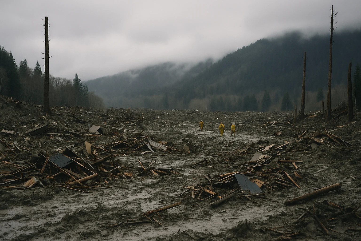
In those first minutes, chaos. People who’d been indoors found themselves thrown hundreds of feet inside the debris, riding mattresses or crumpled walls. Giant trees snapped or disappeared. The mud was thick, sucking people and objects down as it flowed. The slide ran all the way across the valley, crossed the river, and climbed partway up the opposite bank—a debris field over a mile wide, in places seventy feet deep.
The river itself vanished, dammed by tons of mud and trees. Upstream, water pooled, threatening new floods. Downstream, dust and fragments wafted in the wet air.
Neighbors dug with bare hands or whatever tools they could find, calling out names and sifting mud. Some made it out—eight people, in the end, survived after being rescued or crawling free. One man described clawing his way up from below, blinking into sudden daylight: “It was all gone. Everything.”
The Search for Life: “We’re Not Leaving Anyone Behind”
First responders hurried in—firefighters, police, volunteers. But the devastation defied belief. Oscar Escalante, a firefighter who responded that day, told local media: “We’d never seen anything like it. It wasn’t a landslide. It was a valley wiped clean.” The field was unstable, dangerous even to those trying to help.
Helicopters hovered, lowering searchers into the chaotic mess. Search dogs picked over broken lumber and thigh-deep muck. The National Guard arrived. So did teams from FEMA and the U.S. Army Corps of Engineers, but the mud made heavy machinery nearly useless in the early days. Rain kept falling. The river backed up, threatening to wash away what was left.
For the families waiting on the edges, hope was hard—“but you don’t stop,” as another volunteer put it. The search went on day and night, for weeks. Most of the missing were recovered in the first two months, but it wasn’t until July—four months later—that the last victim was found and brought home.
When the final tally came, 43 people had died. Many families lost several generations. Some of the injured would carry physical and mental scars for years.
What Was Left: Displacement, Damage, and the Long Grief
When the slide finally settled, it had erased almost everything in its path. Not just homes, but memories—photo albums, pets, family heirlooms. The property damage alone was estimated around $60 million. Nearly fifty homes, flattened or entombed in mud.
The loss stretched further. The region’s main road, State Route 530, was destroyed for months, severing the link between eastern and western Snohomish County. Businesses closed. Emergency services re-routed. The reopened highway, months later, cut a new scar through the still raw landscape.
The Stillaguamish, dammed by the debris, threatened to flood upstream with every new rain. The Army Corps of Engineers raced to cut a bypass, stabilize banks, and reroute the river. Environmental concerns spanned years—fish runs, water quality, soil stability.
But the heartache was concentrated. Dozens of families were not just displaced, but torn apart. The town of Oso, already small, faced funerals, memorials, and the endless, unanswerable question: Could we have known? Could we have prevented this?
The Response: A Community, State, and Nation Rallied
If tragedy unlocks character, Oso’s devastation was answered with resolve. Rescue workers, volunteers, and neighbors—some who lost family and homes themselves—doggedly picked through the debris, not content to wait for official orders. Cafés opened as makeshift supply centers. Churches and schools collected donations.
State and federal agencies acted as best they could. President Obama declared a disaster area; FEMA sent help. Financial assistance went to the newly homeless. Psychologists arrived to counsel children and families. NGOs rebuilt playgrounds, provided temporary shelter, and delivered meals.
Meanwhile, engineers addressed the immediate: clearing highway rubble, reestablishing communication lines, and designing new bridges over the river. The natural dam was monitored hourly, and in the summer, as the river found its way, a bypass finally diverted the threat of flooding.
Who Knew, and When? The Search for Accountability
As recovery began, hard questions followed. Snohomish County and Washington State faced scrutiny for allowing new homes to be built in a known landslide hazard zone. Lawsuits soon arrived, filed by the families of the dead and injured. In the archives, geologists and county records showed that while risk was mapped, few residents truly understood the depth of the threat.
One local geologist later said: “We knew it could move. But nobody thought it would go that far or fast.” In 2016, several multimillion-dollar settlements were paid to victims’ families, and internal reviews up and down the government chain exposed failures in risk communication.
Researchers pointed to logging on the slope as a possible contributor, though debate persists. The consensus, however, fell on nature’s brute force: relentless rain, unconsolidated glacial soil, and deep instability—together forming a rare, catastrophic combination.
Learning the Hard Lessons: Aftermath and What’s Changed
The Oso Mudslide did more than take lives. It forced a reckoning in how communities read the land—and listen to what it’s telling us. In its wake, hazard maps were redrawn statewide. Emergency notification systems grew more robust. Counties and towns across the Pacific Northwest—some of the most landslide-prone real estate in the country—started to take landslide risk seriously.
The U.S. Geological Survey and scientists from across the world descended on Oso to study the site. They mapped the slide, drilled core samples, and refined models for predicting when “the next big one” might come somewhere else. Funding for hazard mapping and warning systems increased in both Washington and Oregon.
Most of all, the town changed. The memory of the lost is etched now in a memorial just off the rebuilt highway, a plain but moving place—forty-three stones, one for each life taken. Each spring, the community gathers: for laughter, prayers, and, inevitably, tears.
The Meaning of Oso
Disasters rarely feel “historic” when you’re inside them. For Oso, March 22, 2014, will always be both an ordinary day and the moment everything shifted. It is a before and after, the story of a valley and the people who called it home.
Nearly a decade later, the echoes remain. You can still see the scar on the landscape—a raw band at the edge of deep green forest. For those nearby, the slide is a warning, a lesson in humility before the power of earth and weather.
But it is, just as much, a testament. To the courage of first responders. To the tenacity of searchers who wouldn’t stop. To neighbors who lost everything, but held on to one another. And to the memory of forty-three, whose names will not be forgotten, written into the story of a hillside that, for one terrible morning, would not hold.
Stay in the Loop!
Become a Calamity Insider and get exclusive Calamity Calendar updates delivered straight to your inbox.
Thanks! You're now subscribed.