1991 Eruption of Mount Pinatubo
by: The Calamity Calendar Team
June 15, 1991
The Sleeping Giant Awakes
Just before dawn one morning in June 1991, the world changed for hundreds of thousands of people in Central Luzon, Philippines. By then, a thick, unnatural gloom had settled over the farmlands and forests surrounding Mount Pinatubo. The sun barely pierced heavy, metallic clouds. Even chickens—usually up at the slightest hint of morning—stayed silent under the oppressive weight of ash.
People had long lived in the shadow of Pinatubo. For the Aeta, the mountain was both a home and a namesake. To lowland farming families, it was part of the horizon—a half-forgotten fixture on the northwestern edge of Luzon. Mount Pinatubo had been asleep for centuries, more than 500 years by most accounts. Its old eruptions were legend, not memory.
But by March of 1991, that old certainty began to crumble. Smoke and strange tremors. Government scientists and Americans from Clark Air Base huddled over seismic monitors, their faces reflecting back lines that leapt with every shudder beneath the earth. At first, most people called it fuss over nothing. Villages carried on. Buses ran. Rice was planted. But the ground kept moving.
A chain of events had been set in motion that no one—scientist, soldier, or farmer—could reverse.
Cracks in the Calm
The story of the 1991 Pinatubo eruption, in some ways, is a story of warnings: some heeded, some ignored, others outstripped by the force of nature.
In early April, cracks appeared along old riverbeds and trails. On April 2, with little fanfare but a sky choked by gray, Pinatubo belched its first plumes in five centuries. Steam-driven explosions—phreatic blasts—shot ashy columns into the air. Locals watched as fine dust drifted through the banana groves, coating carabao and chickens in a ghostly film. Some shrugged, saying even the oldest village elders had never seen the mountain truly angry.
Thanks for subscribing!
But scientists with the Philippine Institute of Volcanology and Seismology (PHIVOLCS) and the United States Geological Survey (USGS) saw what was coming. Each week, their readings grew more urgent: swelling ground, surges of sulfur gas, and deepening earthquakes. In May, they hammered warning signs into the roads around Pinatubo and shared frightening projections at hastily called barangay meetings. Evacuation lines began to snake away from the volcano. By early June, thousands had left homes behind—some with just the clothes they wore, others carting what they could on tricycles or on foot.
The military pulled out the last dependents from Clark Air Base and started weighing some unimaginable decisions. Subic Bay Naval Base, too, braced for disaster. For a sprawling region already alive with the anxious rhythms of monsoon season, the tension became nearly physical—each new gust of wind could carry rain, or ash, or both.
The volcano, meanwhile, was swelling—physically bulging by almost 200 meters at its crown—a monstrous sign of the magma pushing to the surface.
June 12–15: The Sky Falls
It was Philippine Independence Day, June 12, when Pinatubo unfurled its first violent volley skyward—a thick, boiling column of ash punching 19 kilometers into the heavens. For three days, the mountain pulsed and groaned. Then, on June 15, with the region already battered by the rain-laden winds of Typhoon Yunya, the real catastrophe arrived.
At 1:42 p.m., in the shadow of racing storm clouds, Mount Pinatubo unleashed itself. For hours, the sky turned black and the air grew so thick with ash and pumice that day became night. The eruption column eclipsed 34 kilometers, reaching the stratosphere and sending shockwaves that rattled windows 90 kilometers away in Manila.
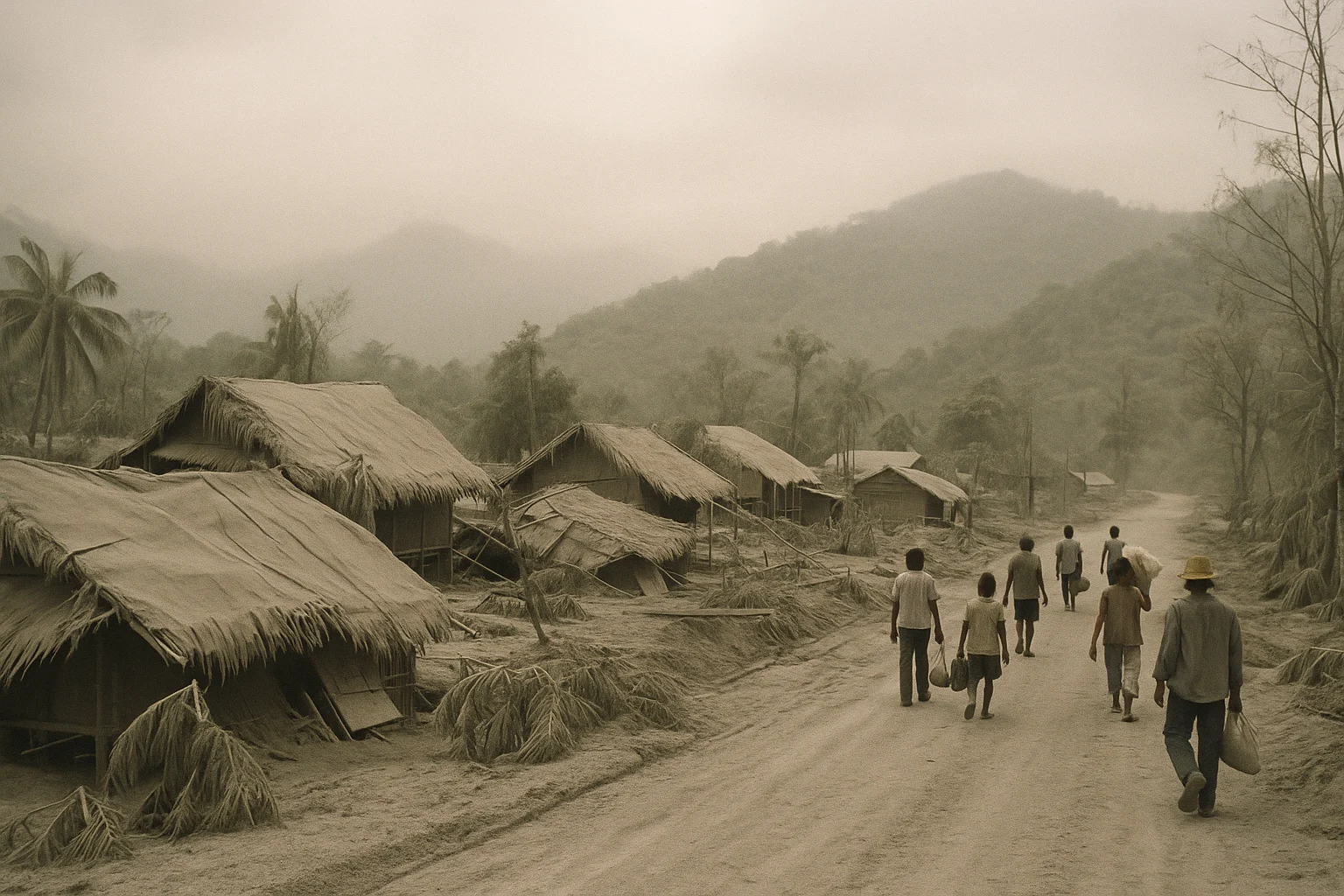
Villages vanished under surges of ash. Pyroclastic flows—clouds of superheated gas, stones, and debris—swept down the mountainsides at terrifying speed. Some Aeta families, fleeing on foot, watched their forests disappear behind roiling curtains of gray. The ash and rain formed quicksand-like lahars that surged down rivers and through towns, swamping everything in their path.
Under a sky that looked like the end of the world, tin roofs and nipa huts buckled under the sodden gray burden. People huddled in churches, schoolhouses, and makeshift shelters, listening to the creaking of beams as the weight built up. Many never made it out: of the nearly 850 officially counted dead, most died when their roofs collapsed around them—sudden, silent suffocation.
Some survivors later described the sound as a “continuous thunder.” Others remembered the darkness—so thick, they couldn’t see their own hands, and the only light for hours came from lightning crackling within the ash cloud itself.
Aftershocks: Loss, Grief, and Broad Shadows
The eruption didn’t end in a moment. In the hours and days that followed, the world seemed knocked off its familiar balance. The ash cloud’s eruption—estimated at more than 5 cubic kilometers of material—blanketed 400 square kilometers. Towns, highways, and fields disappeared under layers of volcanic debris. Even days away by truck, Manila and other far-off locations saw sheets of fine powder coating car windshields and clogging rivers.
For those who survived, the disaster kept unfolding. The Typhoon—its name was Yunya—refused to relent. The combination of heavy rain and falling ash sent lahars barreling down mountain rivers, swallowing bridges, houses, and entire orchards in mud and stones. The very earth itself moved: old river valleys filled up, new lakes formed, whole communities were forced to abandon their homes as the land changed beneath them.
The numbers alone tell only part of the story:
Over 1,000 people wounded—some by burns, others by collapsing homes or landslides.
More than 200,000 left homeless, and some 2.1 million affected by loss of shelter, food, or livelihood.
Infrastructure—roads, power lines, water systems—reduced in places to tangled wreckage or simply erased.
Livestock killed, crops ruined, wild forests scoured clean of life.
Among the displaced were the Aeta, people indigenous to Pinatubo’s slopes for generations. Their villages were gone. The landscape that had fed and protected them was now alien—barren, reshaped, dangerous. Many scattered to evacuation centers or uncertain resettlement areas, their way of life ruptured overnight.
International attention fell upon the region as scenes of devastation circulated worldwide. But for those pulling the pieces together on the ground—mothers searching ruined kitchens for salvageable pots, farmers checking the skeletal carcasses of carabao—the losses felt intensely personal.
Unseen Waves: Global Consequences
Mount Pinatubo did not just alter Luzon; it sent ripples across the planet. Up in the thin blue of the stratosphere, the volcano injected some 20 million tons of sulfur dioxide, a blistering acid haze that circled the globe. Small particles—known as aerosols—reflected sunlight away, cooling global temperatures by about half a degree Celsius in the year that followed.
The sunsets were famously spectacular for months, painted in strange purples and oranges even as far away as Europe and the Americas. But meteorologists linked droughts and cold snaps to the shadow of Pinatubo. It became a grim but useful lesson for climate scientists: one mountain, one day, could reshape weather worldwide.
For the United States and the Philippines, the disaster had another side effect. Clark Air Base and Subic Bay, once among the largest overseas military installations in Asia, were so damaged by ash and lahar that the decision to evacuate became a final one. By the end of 1992, both bases had been turned over to the Philippine government—a geopolitical shift hastened by a mountain’s fury.
Picking Up the Pieces
Amid chaos, there were quiet triumphs—and hard lessons learned. Early and aggressive evacuations saved thousands of lives, a testament to the scientific warnings and the willingness of communities to heed them. The US and Philippine militaries, along with international charities, coordinated immense relief campaigns: food, water, shelter, and medicine for hundreds of thousands pouring into evacuation sites.
But recovery wasn’t neat. The counties hardest hit—Pampanga, Tarlac, Zambales—struggled not just with loss but with uncertainty. Lahar floods didn’t stop when the eruption ended; for years afterward, every rainy season would bring new mudflows, new evacuations, fresh grief. Houses had to be built on stilts or reinforced. Governments hired river engineers and constructed lahar dams to try to tame the changed rivers.
Relocation proved especially traumatic for the Aeta. Many resettlement camps were ill-suited to their needs: far from ancestral lands, crowded, short of clean water. Their struggle for recognition and restoration is a story that continues even now, a slow reckoning with what disaster and government policy can do to a culture.
The land, too, has memory. Large tracts of forest and farmland have only lately begun to recover. Some zones—once impossibly lush—have become stark, otherworldly deserts. But on the far edge of Pinatubo’s crater, wildflowers have since returned, and a shimmering turquoise lake now fills the place where the old summit once stood.
Lessons Etched in Ash
Three decades later, Pinatubo’s legacy is everywhere. The disaster reshaped the way the Philippines—and the world—thinks about volcanoes and the risks they carry. PHIVOLCS became a model for volcanic hazard monitoring in Southeast Asia, investing in new instruments, public education, and mapping. Governments learned, sometimes the hard way, that listening to warnings and planning early saves lives.
From the ashes grew new stories: of resilience, recovery, and, slowly, healing. Villages have been rebuilt, and the “apocalyptic” landscape near the crater has become a surprising tourist draw for hikers and travelers coming to see earth’s powers on fierce display.
But for many—for the Aeta, the survivors, those who lost homes and loved ones—the scars, both visible and invisible, remain. The 1991 eruption of Mount Pinatubo stands as a reminder: sometimes, history erupts in a day, but its echoes last far longer.
The mountain, now ringed by trees and a tranquil crater lake, watches on.
Stay in the Loop!
Become a Calamity Insider and get exclusive Calamity Calendar updates delivered straight to your inbox.
Thanks! You're now subscribed.